Traffic Impact

Published:

Updated: August 20, 2024

West Kessler Neighbor Pickets against the Rezoning
West Kessler Neighbor protests against the Rezoning in 2015.

The traffic implications of this proposed multi-family development are many.  It doesn’t take a traffic engineer to know that Hampton Road suffers from over-use and congestion.  But just because Hampton has a low level of service due to it’s over-use doesn’t mean that we shouldn’t be concerned about adding to or making the traffic worse.

Hampton Road is not the only road that will be impacted negatively by this project. North Boulevard Terrace, a dead-end street that runs parallel and to the west of Hampton will be connected to Plymouth Rd to the north as part of this project. In the 2017 Bond process, our current Council Member Chad West was the Chair of the Citizen Bond Task Force and was responsible for getting this connector road on the needs list. To make the $2.2M connector road possible, some privately owned land had to be seized through eminent domain.

A $2.2M connector bridge will connect N. Boulevard Terrace to Plymouth Road. A project designed to clearly help the developer, current property owners no longer live on a cul-de-sac.

Imagine how you would feel if your quiet cul-de-sac became a major cut-through for literally thousands of cars trying to avoid traffic on N Hampton Rd. — and all this to help a developer/city official make the money of a life time. And to add insult to unjury, private property was seized to do so. It is entirely disingenuous, when the developer says he did not want the bridge. In fact, in 2015 he said the only reason he had to put his ingress/egress onto Hampton Rd was because a bridge to Plymouth was cost-prohibitive and would make his project unprofitable. And other propaganda, that the City HAD to build the bridge to provide access for emergency vehicles is a false narrative. A turn-about at the end of the street would have been another viable and cheaper option.

The developer has expressed his belief that Hampton is “broken” and it’s traffic problem is a larger issue that needs to be addressed at the city wide regional level.  Despite his acknowledgement of the issues related to traffic on Hampton Road, he makes no apologies or excuses for adding more vehicles to the already congested Hampton Road by seeking to develop a high density multi-family development.  The developer’s “its-broken-so-who-cares” mentality is fundamentally wrong and irresponsible.

This graph illustrates the congestion along N Hampton Road. This proposed high density multi-family development will allow the developer to disproportionately push traffic counts towards or above the dysfunctional threshold.

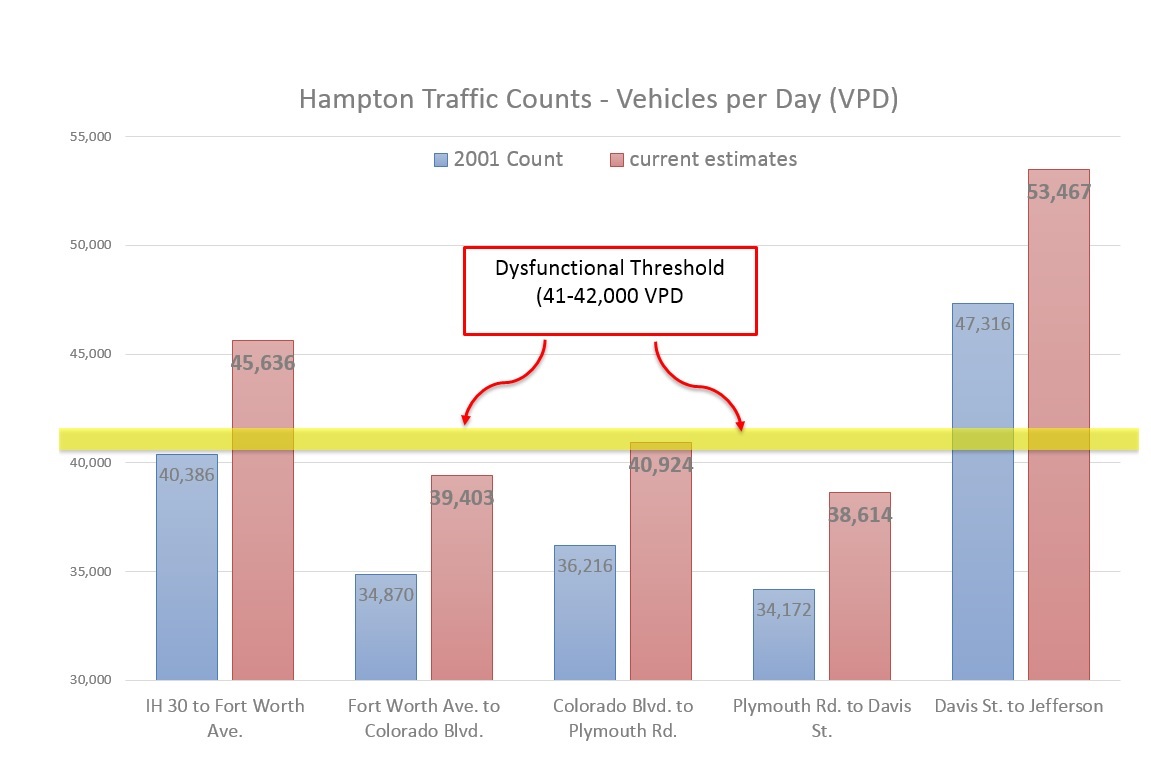
The image above graphically illustrates traffic counts along Hampton Road from I-30 to Davis.  The segment of Hampton directly in front of the proposed multi-family development has approximately 39,000 vehicles per day.  Its important to recognize that Hampton Rd can not be widened any more.  There is no higher capacity thoroughfare designation to which  Hampton can be promoted — it wall always be a six-lane divided thoroughfare. Since Hampton Road can not be widened, the 39,000 daily commuters, the nearby home owners and the community in general have a vested interest in maintaining the highest level of service on Hampton for as long as feasibly possible.  Thus, this proposed high density multi-family development is counter to and undermines the general public interest.

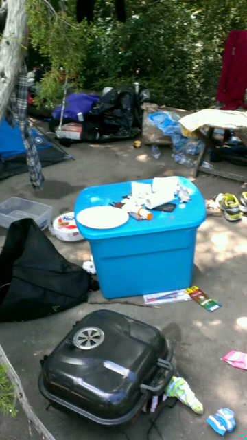
The picture below supports the position that Hampton Road presents real risk to health and safety. These risks DO NOT need to be increased by unnecessarily contributing to increased traffic in an already over-utilized thoroughfare.

This speeding car lost control trying to avoid a car making a U-turn at the median break.
FacebooktwitterFacebooktwitter

Why should ten single-family parcels be rezoned to benefit one single person?

Published:

Updated: August 20, 2024

Christian Chernock is petitioning the City of Dallas to allow him to build a 100-unit apartment complex, four 8-Plex apartment buildings and 13 houses on 10 single-family parcels. (Case numbers  Z234-244 and Z234-249).  This proposed development, plain and simple, is high density multi-family right in the middle of a well-established single-family neighborhood. It will have 150 units total and a density of greater than 32 units/acre that is 10x greater than the current zoning allows.

Color-coded map illustrates current land use patterns. For orientation purposes, Hampton runs top to bottom near the center of the image. The yellow area near the center of the image is the proposed  development that is surrounded mostly by the single-family parcels of both the West Kessler and N. Boulevard Terrace neighborhoods. Even though there are some other developments on the outer edges of this neighborhood, their density is 1/3 to 1/10 of the proposed density.

It is important to understand, that he was previously denied a rezoning request by the City Council but since then, with the help of Chad West as Chair of the 2017 Bond Citizen Task Force, our tax dollars will build him a $2.2M dollar bridge that required seizing land by eminent domain. And in a blatant violation of the City’s Code of Ethics for City Officials, he filed this massive upzoning request while sitting on the Plan Commission. Regardless of the serious ethical questions that exist, a quick review of the color-coded map above makes it clear that that this rezoning request is contrary to a greater comprehensive land use plan. Moreover, the rezoning request disregards established buffer zones that exist between multi and single-family districts within the area.

Coombs Creek Buffer Zone
Coomb’s Creek (outlined in green) provides a well-established buffer between the high density multi-family apartments (upper left of center) and the single-family neighborhoods of El Tivoli (middle left) and West Kessler (bottom and right). This is not a coincidence, but rather a deliberate planning strategy to mitigate the impact multifamily density can have on single-family districts.


The power bestowed to local municipalities to regulate land use comes directly from our State Constitution. Home owners whose homes frequently represent their single largest asset, commit to 15, 20 or 30 year mortgages to procure their homes. These home owners have a reasonable expectation that the single-family district into which they have invested will not be drastically rezoned such that it would unduly impose on the use and enjoyment of their property. In fact, Texas statute says that zoning should be “in accordance with a comprehensive plan” designed to “lessen congestion”, promote safety, health and welfare, provide “light and air, “prevent overcrowding,” avoid “undue concentration of population,” and facilitate transportation, utilities and other facilities. (TEX. LOC. GOV’T CODE §211.004)

FacebooktwitterFacebooktwitter

Pocket Neighborhood – NOT!

Published:

Architect Ross Chapin's Book, "Pocket Neighborhoods: Creating Small-Scale Community in a Large-Scale World"
Architect Ross Chapin’s Book, “Pocket Neighborhoods: Creating Small-Scale Community in a Large-Scale World”

The developer has been promoting Architect Ross Chapin’s book, Pocket Neighborhoods: Creating Small-Scale Community in a Large-Scale World.  Ross Chapin together with developer, Jim Soules are considered the “grandfathers” of  so-called “pocket” or “cottage” neighborhoods.  Their work in this style of architecture and development began back in the mid-90’s and many of their projects are truly world class.  It’s ironic that Christian Chernock suggests that we read this book, but then chooses to not abide by the architectural and planning guidelines set forth within and incorporated into many municipal zoning regulations. 

We actually contacted Ross Chapin and asked him to review the proposed site plan.  He didn’t have too many complimentary things to say about this proposed development.

Here are some of Ross Chapin’s comments during his review of the proposed development:

  • This is not a pocket neighborhood in its overall design
  • The marketing material is false and misleading
  •  Where are the picnic areas? BBQ? Sun shelters?
  • There are issues with scale, massing, density and lack of detail
  • Not following the cottage code – only paying lip service to the concept
  • This is a automobile dominated configuration
  • There should not be access via Hampton, especially since other access is available – this risks peoples lives
  • There is a plop, plop, plop mentality in this plan that will create a fishbowl effect that creates tension in the community and a resentment to the increased density
  • Needs to be better, safer, pedestrian friendly and visually toned down
  • The major focal point of this site plan is the waste management area
  • The developer needs to look at the design patterns in the book – the patterns that make for good neighbors


More on Pocket Neighborhoods

The driving factor behind the birth of this architectual movement was ultimately a housing shortage — more specifically an affordable housing shortage.  This style of development allows for greater density construction over what traditional single-family zoning would allow. The typical ratio for the smaller cottages is 2:1 and 1.5:1 for the larger designs.  For example, a typical 7,500 square feet single-family parcel could accommodate two 800 square feet cottages.  The advantage, obviously, is a reduction in land costs for the developer. Those dollars could in turn be diverted into a more thoughtful structural design with a higher quality finish.  And ultimately this creates a market product of affordable transitional housing that exists somewhere on the spectrum between cheap row houses on one end and high-end condominiums on the other end (neither of which have high desirability).

In the twenty years that has passed since the inception of this genre of housing, many municipalities have started to experiment with this type of zoning mechanism and many lessons have been learned along the way.  One thing that has become crystal clear is that without proper zoning regulations, this design genre is not sustainable.  To get nearby home owners to accept with open arms this higher density construction standard into their single-family neighborhoods, the development standards of these pocket neighborhoods must be meticulously outlined in stringent zoning code.  If not, any speculative high density  multi-family development could claim that it was a “cottage” or “pocket” neighborhood and try to cash-in on the cheap dirt of a single-family district.  And that is exactly what the developer of the proposed Kessler Commons is attempting.  Several cities that have allowed this type of development through specific zoning ordinances have found that developers, like Christian Chernock, all too frequently exploit and abuse the regulations by squeezing dwelling units into every square inch of land to maximize profits.  Consequently, some of those cities have repealed the ordinances because of the abuse by developers and the detrimental impact on established single-family districts.

Below you will find links to some of the actual zoning regulations from various municipalities that Chapin and Soules have listed in their book as successful examples of cottage neighborhoods.  There are key design aspects that define this genre and Kessler Commons falls way short of the design standards.  

Please feel free to read some of the Cottage Neighborhood zoning regulations below from some of the cities that are home to Chapin’s most successful Cottage Neighborhood developments.  In doing so, you will see just how disingenuous it is that the developer is claiming his proposed high density, multi-family development is a “cottage” or “pocket” neighborhood.

Shoreline Washington

Seattle

King County Housing Alliance

Redmond

City of Mukilteo

Port Townsend

King County

Marysville

Federal Way

FacebooktwitterFacebooktwitter

Real Pocket Neighborhoods

Published:

Lets look at the actual cottage neighborhoods that Ross Chapin and Jim Soules have designed and built.  Purportedly, Kessler Commons was modeled after these award-winning neighborhoods but the images below tell another story entirely.  The high density, multi-family development that Christian Chernock is proposing is vastly different from any of the Chapin-designed neighborhoods.  He is proposing 42 units on 3.6 acres! And, not one of the Chapin designed cottage neighborhoods include Town Homes.

DEVELOPMENTCITYSTATEUNITSAVG SQ FTTOTAL ACREAGEFEATURES
Backyard NeighborhoodWhidbey IslandWA3 + 31200 + 4650.53 homes + 3 backyard cottages
Conover CommonsRedmondWA2518009.52 miles from MicroSoft HQ
Danielson GroveSeattleWA1610001.8700 - 1500 sq ft
Ericksen CottagesBainbridge IslandWA1115001.1walking distance to Ferry
Greenwood Avenue CottagesShorelineWA89000.8across from community college
Ravenna CottagesSeattleWA6 + 3850.256 homes + 3 carriage houses
Third Street CottagesLangleyWA81000.66on Whidbey Island
Backyard Neighborhood - 3 homes plus 3 backyard cottages
Backyard Neighborhood – 3 homes plus 3 backyard cottages
Conover Commons - 2 phases, 25 total units on 9.5 acres
Conover Commons – 2 phases, 25 total units on 9.5 acres
Conover Commons
Conover Commons
Danielson Grove - 16 units on 1.8 acres
Danielson Grove – 16 units on 1.8 acres
Danielson Grove Street View
Ericksen Cottages - 11 units on 1.1 acres
Ericksen Cottages – 11 units on 1.1 acres
Ericksen Cottages Street View
Greenwood Avenue Cottages - 8 units on 1 acre
Greenwood Avenue Cottages – 8 units on 1 acre
Greenwood Avenue Cottages
Ravenna Cottages - 6 homes + 3 carriage houses on .25 acres
Ravenna Cottages – 6 homes + 3 carriage houses on .25 acres
Ravenna Cottages
Ravenna Cottages
Ravenna Cottages Street View
Third Street Cottages
Third Street Cottages – 8 units on 2/3 of an acre
Third Street Cottages - 8 units on 2/3 of an acre
Third Street Cottages – 8 units on 2/3 of an acre
FacebooktwitterFacebooktwitter

Home Values Analysis

Published:

The developer of this proposed high density, multi-family subdivision (its clearly not a cottage neighborhood) has suggested that the parcels involved are “blighted” and that the neighborhood will benefit greatly from this development.

So lets look at some of the numbers with respect to property values on North Boulevard Terrace.

Chernock's properties show the greatest 5 year decline in value.
Chernock’s properties show the greatest 5 year decline in value.


Chernock's properties are the lowest valued on North Boulevard Terrace.
Chernock’s properties are the lowest valued on North Boulevard Terrace.

These figures above related to the property values on North Boulevard Terrace clearly illustrate that Chernock’s properties are the lowest valued properties.  Moreover, Chernock’s properties have had the sharpest 5 year decline in values versus the other North Boulevard Terrace properties.  So it appears that the “neighborhood blight” to which the developer refers is largely due to the neglect of his own property. Coincidence? Or is it an attempt to keep property values artificially low for the purposes of acquisition?

And what about the property values on N Hampton Road? Lets take a look.

Properties on Hampton Road show solid gain in values of 5 years.


Hampton home values are comparable to other West Kessler properties.

The figures above related to property values on Hampton Rd clearly illustrate solid gains in value over the past 5 years. Additionally, the average home values are comparable to or greater than other areas within West Kessler.  Contrary to arguments made by the developer, this segment of Hampton Road does NOT need to be “rescued”.

Please note the picture below of a homeless camp that was discovered on, yes you guessed it, Chernock’s property!

Homeless camp discovered on Chernock's property.
Homeless camp discovered on Chernock’s property.
FacebooktwitterFacebooktwitter

Conceptual Plan

Published:

Updated: August 20, 2024

The Developer has 2 zoning cases for the 10 single-family parcels in what is a transparent attempt to limit the notification zone and the trigger for a traffic study.

This shows the location of the development within a single-family district. Hampton Road runs top to bottom in center of image and Davis runs left to right at bottom of image.

Z234-244: Plan is to have six single-family parcels on the west side of North Boulevard Terrace be rezoned to MF-2 so he can build a 100-unit apartment complex. Since this is not a request for a Planned Development District (PD), the notification zone is only 200 feet.

Z234-249: Plan is to have four single-family parcels on Hampton rezoned to a Planned Development District (PD) consisting of four 8-Plex apartment buildings and 13 homes that may, or may not be detached. Because this is a PD, the notification zone is 500 feet.

Bottom Line: Existing zoning on these single-family parcels allows for about 3-4 units per acre. He is asking for more than 10x the existing zoning for an average of 32 units per acre.

On the left side of the image above Six single-family parcels to be upzoned to Multi-family for a 100-unit apartment complex. On the right side, four single-family homes will be torn down to build four 8-plex apartment buildings, and 13 houses.


FacebooktwitterFacebooktwitter